One of a series of local walks produced by
Aston on Trent Local History Group
*More detailed route information and other footpath links can be found on OS Explorer Maps 245/259.
If you have mobility issues please check first

Aston on Trent History Walks
Number: 1
(South Aston)
3.5 miles / 5.6 kms
Approximate time 1 – 1.25 hours
Flat easy walking. Most walks use countryside footpaths. Please consider weather and ground conditions.
This pack contains a basic map, route directions * and history notes
Aston on Trent History Walks
Number 1 (Aston South)
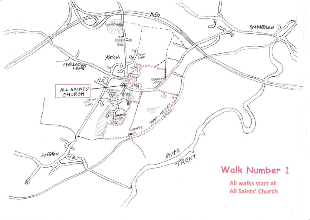
- Start at the church and go to Derby Road and The White Hart Pub. Cross Derby Road keeping to the left of The Green (1) towards Manor Farm Road for about 75 yards.
- Bear left down narrow Clarkes Lane. After 50 yards turn left at the grass area down the narrow alley, turn right into Manor Farm Road.
- Look for a sign Manor Farm Road leading to Little Moorside. (2) Follow this track to the gates of 66 Moor Cottage and take the narrow path on the left of the gates. Continue to a stile and follow the footpath crossing a field to a bridge over a stream, bear right across the next field.
- Arriving at a track turn right towards Shardlow Road.
- On reaching Shardlow Road turn right, join pavement leading towards Aston.
- At the bend in the road opposite the Severn Trent Water Pumping Station there is a point on the bend where a good long distance view of the road in both directions can be obtained. If safe to cross go through the barrier onto the track to Aston Lock.
- Along this track you will pass over the Aston Cursus and Bronze Age burial sites. (3) These are Ancient Scheduled Monuments and the location can be recognised by the uncultivated area of field on the right of the track.
- On reaching the Trent and Mersey Canal (4) turn right and follow the towpath to bridge 7 at Weston Grange. (5)
- Cross the bridge and keeping to the left follow the track towards Weston.
- On the right you approach Long Walk Wood turn right onto the field track keeping the wood on your left.
- Follow the field to the new houses and turn right staying on the field track.
- On the left you will see a single step up onto a pathway which takes you through Middle Wood. Richmond Retirement Village (6) is to your left. Keep to the right on the path.
- You will leave the wood through a wooden gate and about 30 yards on take a path on the right which leads to Aston Hall Lake. (7)
- Continue round the lake path for around 50yds turn right and in about 50yds join the gravelled bridle path turn left. This takes you to Aston Playing fields.
- Walk diagonally left across the Playing Fields and onto Greatorex Walk/ Aston Lodge Estate (8) which takes you back to Shardlow Road, turn right and on your right is the Gables 1A, the site of the old Village Community Hall which then became the Aston Post Office (9), you then come to the centre of Aston village. The end of the walk.
Items of Historic Interest – Walk Number 1
1 Yeoman House No. 16 The Green. This building started life as a farm house working land on which part of Manor Farm Housing Estate was built in the 1960/70s. The Yeoman House was destined for demolition but Aston residents organised a petition and saved it after which it was converted internally to apartments and office space. A date stone for 1690 is located at its first floor level.
2 Little Moorside – A few old cottages situated opposite the end of Clarkes Lane. At one time in the past they were referred to as Near Moorside to distinguish them from a group of cottages towards Shardlow which took the name Far Moorside. The name Moor originates from Aston Moor which was located to the north-east of the village.
3 Aston Cursus – Lying about halfway between Shardlow Road and Aston Lock and on the right of the track there is a parcel of uncultivated land of about one acre in size. This area is a Listed Scheduled Monument through which passes the Aston Cursus. The Cursus is a Neolithic earthwork and dates to c.3500 BC. It would have taken the form of two parallel ditches and runs in a southwest to north east direction from Weston Grange farm towards Shardlow. It would have most likely been used for ritualistic purposes such as ancestor veneration for example. The area also contains Bronze Age burials. Many of these archaeological features were identified using aerial photography
4 Aston Lock -The Trent and Mersey canal was completed in 1777. At one time there
existed a lock keeper’s house located on the grass area adjacent to the lock.
5 Weston Grange Farm The word ‘Grange’ was usually associated with a farm which supplied produce to an abbey or priory. It is likely that the house was built towards the end of the 18th century.
6 Richmond Retirement Village -After passing alongside Long Walk Wood and turning left down the field edge track the modern development on the left is Richmond Retirement Village which opened to accept its first residents towards the end of 2015.
7 Aston Hall Lake/Fish Pond The lake was an important part of the old estate, providing fish and shellfish for the household. In winter ice would be taken from the lake to fill the ice house in Middle Wood. The lake would also have been used for pleasure boating. Water for the Hall was provided by a spring which then flowed into the lake
8 Aston Lodge -A large 18th century house with extensive grounds demolished in 1932/3. Lodge Estate, Park View, Greatorex Walk and most of Aston Playing Fields were built or established on land belonging to the former Aston Lodge. Notsa Engineering Company Ltd., a notable engineering company, was established on the site of The Lodge squash court . Notsa manufactured precision components, including measuring equipment, up to 1984 when manufacturing was transferred away from Aston. The original ornate wrought iron entrance gates to the The Lodge, reliably attributed to Robert Bakewell, were sold at auction for £33.00 and now grace the entrance to West Park, Long Eaton.
9 Aston Old Post Office. –Turning right out of Lodge Estate the building on the right, The Gables, 1A was formerly Aston’s village hall which in later years became the local Post Office.