One of a series of local walks produced by
Aston on Trent Local History Group
*More detailed route information and other footpath links can be found on OS Explorer Maps 245/259.
If you have mobility issues please check first
Aston on Trent History Walks
Number: 2
(North Aston )
2.2 miles / 3.5 kms
Approximate time – 1 -1.25 hours
Flat easy walking. Most walks use countryside footpaths. Please consider weather and ground conditions.
This pack contains a basic map, route directions * and history notes
Aston on Trent History Walks
Number 2: (North Aston)
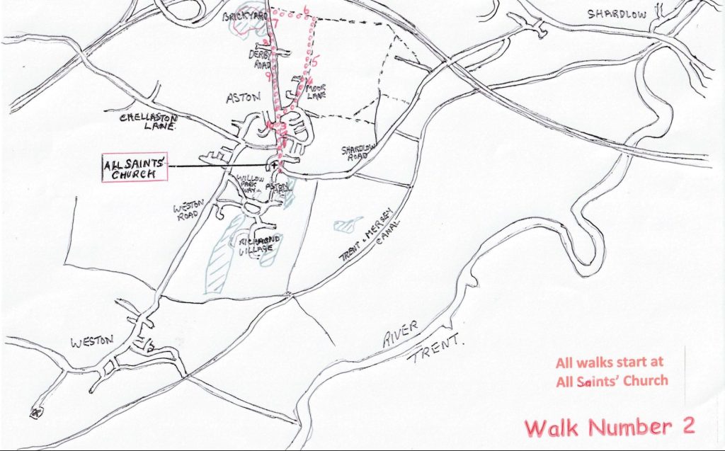
- Start your walk at All Saints’ Church and head north along Derby Road passing the old pump (1) and The Green (2)
- Pass the Victorian Old School House (3) and in 50 yards turn right into Moor Lane
- After 100 yards bear left on Moor Lane. Pass the cemetery and Hanger Bank (4)then continue along the footpath track beyond the last house passing the ‘Lions’ at Clover Leaf Farm (5) through trees to emerge on to a farm driveway.
- Continue north passing Birds Nest farm and a haulage yard to the footpath sign at the corner of a field.
- Turn left (West) to follow a narrow track between a hedge row and green fencing. You are now on the 18th century Tramway (6) between The Brickyard Plantation and the Trent & Mersey Canal
- Cross a stile and climb steps to Derby Road, turn left back to Aston
- After 80 yards cross the road to enter the historic Aston Brickyard Plantation Local Nature Reserve (7)via the swing gate
- Take the left or right track by the green cabin and follow the circular perimeter track back to the entrance gate.
- Turn right down Derby Road to Aston on Trent village passing the site of. Alderslade Farm (8) at Hill Crest. A little way down on the right is number 95. Here the Mine Tramway (9) turned right to go to the mines on the hill.
- On the corner of Long Croft (10) is the former 16th century farm house redeveloped in the 1970s.
- Continue on Derby Rd to the Village centre, and on to the Church.
We hope you enjoyed your walk. Find more at www.astonontrenthistory.org.uk
Items of Historic Interest Walk number 2
1. The Pump Erected in 1870 this pump provided water for many of the cottages in and around The Green until mains water came to Aston in the mid 1920s. Worthy of note are the unusual fish scale roof tiles. At one time it served as a bus stop shelter.
2. The Green The heart of its triangular shape served as a venue for many village functions such as an annual fair, granted to the Abbey of Chester by King Henry II in 1257. The Abbey of Chester owned the Manor of Weston, which included Aston, until 1547. Between Pump Cottage and the corner opposite The White Hart stood a row of cottages which were demolished in 1967 as being unfit for human habitation. The remaining older cottages date back to the late eighteenth century.
3. The Old School The land for the Old School was donated by Sir Richard Wilmot in 1844 with the condition that it should be used for the “education of the lower and labouring classes”. The building costs were provided by the Holden family of Aston Hall. The Holden crest (Moorcock rising sable d’or) can be seen above the front door. The Old School was closed in 1984 when its replacement was built on Long Croft.
4. Hanger Bank A cul-de-sac consisting of a former farmhouse and a few modern dwellings. In the 1920s Hanger Bank was a small holding of 5 acres. The name Hanger is an Old English term for a wood on the side of a steep hill.
5 Clover Leaf Farm Established in 1988 this farm/smallholding was known as Clover Leaf Rabbit Farm. Rabbits were bred for export to the continent but this enterprise finished in 1998. From then the owners continued to breed and rescue a variety of animals. A notable feature of their activities was the provision of winter quarters for Skegness beach donkeys which eventually led to the establishment of a permanent sanctuary for two donkeys who went by the names of Mathew and Matilda.
6. Tramway The former Tramway ran from the Brickyard Plantation area, now a Nature Reserve, and was used to transport gypsum from mine workings to a wharf situated near Hickins Bridge on the Trent and Mersey canal. The tramway passed through a tunnel which passed under the Derby Road. Evidence of mining for gypsum goes back to the end of the 17th century and into the 18th century when the material, as plaster, was used locally for whitewashing and flooring. Then commercial demand increased, transportation was improved by constructing the Tramway. It opened in 1812 and operated until the early 1900s.
7. Brickyard Plantation From the end of the 18th century brick-making was carried out in this location as a “cottage” industry supplying local needs. From the beginning of the 20th century production of Aston bricks declined until 1930 when the Derby Brick Company opened up new production facilities which continued until the 1960s. The site became a refuse tip until capped with clay. Local residents planted many of the trees seen here today. In 2012 “The Friends of Aston Brickyard” volunteer group was formed, the site achieving the status of a Local Nature Reserve in 2019.
8. Alderslade Farm At the crest of Derby Road hill lies a new development (Hill Crest) built on the site of Alderslade Farm with its very fine Victorian house which, sadly, was demolished in the 1970s
9. The Brickyard/Gypsum tramway was also extended down the Derby Road towards the village, turning right near what is now dwelling number 73 before crossing fields to gain access to the Gypsum mining area on Aston Hill.
10. Longcroft Farm This village centre farmhouse located on the corner of Long Croft is thought to date back to the late 16th century. During part of the farm’s working life it supported a very productive dairy herd supplying milk to the village and the school. The farm was sold for housing development during the 1970s.