One of a series of local walks produced by
Aston on Trent Local History Group
*More detailed route information and other footpath links can be found on OS Explorer Maps 245/259.
If you have mobility issues please check first

Aston on Trent History Walks
Number: 10
(Shardlow – 18th Century Port)
4.8 miles / 7.7 kms
Approximate time – 2.5 hours
Flat easy walking. Most walks use countryside footpaths. Please consider weather and ground conditions.
This pack contains a basic map, route directions * and history notes
Aston on Trent History Walks
Walk 10 (Shardlow: an 18th century inland port
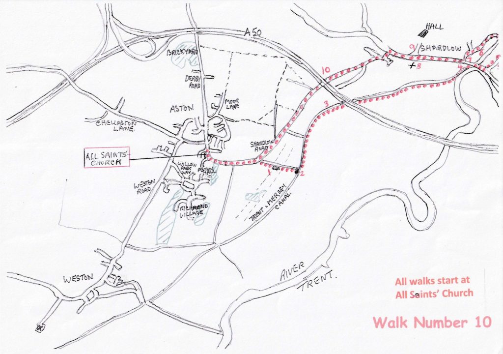
With your back to All Saints’ Church lychgate, turn right for Shardlow. The tall brick building being the remains of Aston Lodge, and follow the road past Shirley Park and the playing fields for half a mile. As the road bends to the left, take the track on your right, through the barrier, past the pumping station. Half way down you will cross the site of the Aston Cursus (1) and an Iron Age burial ground, marked by a square of land on your right. Continue to Aston Lock (2) on the Trent and Mersey Canal, where once stood a lockkeeper’s cottage. Cross the bridge and turn left on the towpath. Passing under bridge No. 5 and, in a further half mile, on the far canal bank stood a Tramway Wharf,(3) near Hicken’s Bridge where gypsum from the mines at Aston was unloaded.
Continue along the towpath, under the A50 to arrive at Shardlow (4), the largest inland port in the country in the 18th century. Sea-going boats could get to and from Shardlow along the River Trent to load/unload their cargos onto the canal barges to continue their journey.
Continue past the lock and Clock Warehouse pub. Keep to the tarmacked roadway as it gently slopes to join the old A6 road. Cross the road and turn right then left into Wilne Lane (5). (This lane goes to Wilne where there was a crossing (ford) on the River Derwent.)
In a quarter of a mile cross the canal bridge and turn left passing the New Inn and the Malt Shovel, ideal for a short stop or lunch.
Continue past The Malt on this road and in a few yards, past a sharp left-hand bend, take a narrow footpath to your right through the alley to enter old Shardlow. To the left is an iron works and on the right the village hall and playing field plus canal warehouses converted into housing. Boat Building(6) has been a major industry in Shardlow for many years.
Continue along the road to arrive at the old A6; across the road is the Shardlow Heritage Centre.(7) Turn right down the long straight road passing the Parish Church of St James(8) and Shardlow Hall.(9) Continue along the road and, at the Dog and Duck Public House, turn left for Aston. Follow this road to cross the A50 Bridge(10) and descend to a driveway on the right. You now have two options.
OPTION 1 Continue along Shardlow Road but CAUTION! There is a grass verge but no footpath or pavement for approx. half a mile. Continue along this road which will return you to the lychgate
OPTION 2 Turn right onto a private road then in 100 yards bear right onto a narrow footpath between trees and parallel to the A50. In a short distance there is a footpath to the left. Take this path across the field and, past the buildings on your left, go straight on passing on your right the rear of Clover Leaf Farm and on to the driveway passing Big Moorside and on to join the Shardlow road where you turn right for Aston and the start of the walk.
We hope you enjoyed your walk. Find more at www.astonontrenthistory.org.uk
Items of historical interest – Walk number 10
1. Aston Cursus The Cursus is one of the largest ancient landmarks in the country, although little can be seen today, there have been “digs” on the site over the years which have revealed artefacts dating back to 3500BC. Originally a pair of parallel ditches over a mile long, it is thought to be a ceremonial construction but there is no confirmed purpose.
2. Canal Lock Cottage. Approaching the Trent and Mersey Canal the clear space to the right housed a lock keeper’s cottage. When canals were busy carrying commercial traffic, it was necessary to have a man who operated the locks. As trade lessoned the house fell into decay and was demolished. 3.Tramway Wharf Just along the canal from the lock was a tramway wharf on the far bank, used for loading gypsum mined at Aston Hill and carried by tramway across the fields. From here it travelled to Weston where it was loaded onto more barges on the River Trent and taken to Kings Mills for processing into several products including plaster for the building trade.
4.Shardlow Inland Port. There are many warehouses in Shardlow some now converted for housing. Shardlow was known as the largest inland port in the country, as in those days coastal vessels could come this far up the Trent, where their cargos were unloaded and stored to await barges which would convey goods further afield. 5.Wilne Lane. This lane leads to Church Wilne village and on to cross the River Derwent near Draycott, in its day an important crossing, but now reduced to a footbridge for walkers. 6.Boat Builders. Shardlow has been a centre for boat building and repair for many years with its central position on the Trent and Mersey canal convenient for trade and related activities. A log boat was uncovered in 1998 in a local quarry, being dated from 1440-1310 BC. It is currently housed in Derby Museum. 7.Shardlow Heritage Centre. This centre is well worth a look round with many interesting artefacts. Discover the history and building of the canal, the river crossings including the Bailey bridge over the Trent and about the cargos which were stored in the warehouses on which Shardlow prospered. 8.St James Church. For many years the people of Shardlow attended Aston Church travelling to Aston by canal boat until the church of St James was built in 1838. Before the church was built coffins were carried by canal for burial in Aston churchyard.
9.Shardlow Hall. Opposite the church is the entrance to Shardlow Hall. Leonard Fosbrooke lived there in 1684 and five generations of his family followed him; he held the position of High Sheriff of Derbyshire twice. In 1911 the Hall became a school and was then converted into offices and a Nursery. The building is Grade 2 listed. 10.A50 bypass Shardlow. Built in the 1990s to relieve traffic passing through Shardlow which was suffering noise and pollution. The road bridge at Shardlow has been reduced to one lane to lessen the weight of traffic using the bridge.